Puslinch By Design: Employment Land Study
What is Puslinch By Design?
Puslinch By Design is a study being completed in partnership with the Township of Puslinch and the County of Wellington to identify additional opportunities for employment lands in Puslinch.
The basis for this study is rooted in the County’s Official Plan Review work. This work identified a minimum 30 hectares needed for additional employment lands in the Township over the long term.
Notice of Application for Official Plan Amendment No. 131 – Rural Growth and Policy Updates
- Notice of Complete Application
- Wellington County OPA #131
- Visit Wellington.ca/planwell for updates regarding the Official Plan Amendment No. 131 Rural Growth and Policy Updates
Why is this area being studied?
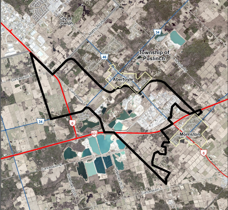
This study area boundary has been selected as a suitable location to look at options for additional employment lands due to its proximity to Highway 401 and Highway 6. It is vital to the economic sustainability of Puslinch and is significant to Wellington County as a whole.
What is the timeline for this study?
Phase 1 – Project Initiation
- Summer/Fall 2024
- Initial meetings, confirming data, and finalizing project schedule
Background Information
- Designated and Listed Properties on Heritage Register – May 2024
- Motor Vehicle Collision and Speed Statistics – OPP Wellington County Detachment
- Puslinch Brand Guidelines
- Puslinch Municipal Development Standards September 2019
- Puslinch Municipal Storm Water Infrastructure
- Puslinch Municipal Water and Sewage Servicing Feasibility Study Report
- Puslinch Municipal Water and Sewage Servicing Feasibility Study Report Addendum
- Township of Puslinch Roads Management Plan
- Township of Puslinch Zoning By-law
- County of Wellington webpage
- Municipal Comprehensive Review webpage
Phase 2 – Existing Conditions
- Summer/Fall 2024
- Research and analysis of topics to consider for Puslinch’s employment lands (examples: transportation, land-use) which will establish the background context
Phase 3 – Detailed Planning Study
- Winter 2025
- Bring together the background conditions and key information necessary to form land-use options for the future employment lands
- Phase 3 – Detailed Planning Study
Phase 4 – Land Use Options
- Winter 2025
- Prepare several Land Use Options reflecting key issues and opportunities for development
- Phase 4 – Land Options Report
- February 26, 2025 Special Council Meeting
Phase 5 – Preferred Land Use Plan
- Spring/Summer 2025
- Outline the rationale for the preferred land use plan, along with the policy designations and maps, infrastructure needs, design guidelines, and implementation guidance
Phase 6 – Recommended Local Development Framework
- Spring/Summer 2025
- Prepare the Official Plan Amendment policies and mapping based on the Preferred Land Use Plan to apply the study’s recommendations